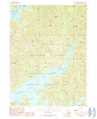
1990 Map of Minnesota Mountain
USGS Topo · Published 1990About this map
Minnesota Mountain and the surrounding high peaks of the Shasta National Forest dominate this landscape, which centers on the intricate shoreline of the Shasta Lake McCloud Arm and Pit River Arm. The 1990 survey captures a region primarily dedicated to recreation and conservation within the Whiskeytown-Shasta-Trinity National Recreation Area. Public access points like the Dekkas Rock Campground, Hirz Bay Campground, and a boat ramp illustrate the transition of this territory from industrial or pioneer use to a managed wilderness destination.
Find a feature on this map
51 named features on this map. Tap any name to fly to it.
Don’t see what you’re looking for? This feature index may not catch every label — zoom into the map to look around manually.
Map Details
Editions of this 1990 Minnesota Mountain Map
This is the sole edition of this map. No revisions or reprints were ever made.
Other maps of this area

1890 · Red Bluff
USGS Topo · 1:250,000

1894 · Red Bluff
USGS Topo · 1:250,000

1901 · Redding
USGS Topo · 1:125,000

1944 · Redding
USGS Topo · 1:62,500

1946 · Lamoine
USGS Topo · 1:62,500

1946 · Redding
USGS Topo · 1:62,500

1949 · Bollibokka Mtn
USGS Topo · 1:62,500

1953 · Millville
USGS Topo · 1:62,500
1957 · Project City
USGS Topo · 1:24,000
1957 · Lamoine
USGS Topo · 1:62,500