
1905 Map of Minnetonka
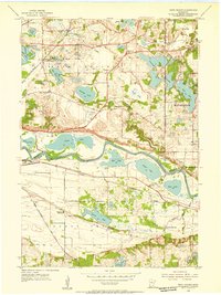
USGS Topo · Published 1957About this map
Lake Minnetonka and the surrounding Minnesota lake country are captured here at the turn of the century, as surveyed in 1905 with shoreline data from the U.S. Army Engineers. The landscape is defined by its complex shoreline, dotted with established summer colonies and landings like Cottagewood, Deephaven, and Minnetonka Beach. A sophisticated transportation network of the era is evident, with the Great Northern RR and the Minneapolis and St Louis RR providing rail access to lakeside stops including Spring Park Sta and Mound Sta.
Find a feature on this map
160 named features on this map. Tap any name to fly to it.
Don’t see what you’re looking for? This feature index may not catch every label — zoom into the map to look around manually.
Map Details
Editions of this 1905 Minnetonka Map
This is the sole edition of this map. No revisions or reprints were ever made.
Other maps of this area

1896 · Minneapolis
USGS Topo · 1:62,500

1901 · Minneapolis
USGS Topo · 1:62,500

1902 · Anoka
USGS Topo · 1:62,500

1907 · Minnetonka
USGS Topo · 1:62,500

1909 · Rockford
USGS Topo · 1:62,500

1953 · Saint Paul
USGS Topo · 1:250,000

1953 · Stillwater
USGS Topo · 1:250,000

1954 · Hopkins
USGS Topo · 1:24,000
1954 · Eden Prairie
USGS Topo · 1:24,000
1954 · Minneapolis
USGS Topo · 1:62,500