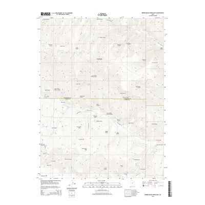
2014 Map of Minnie Maud Creek East
USGS Topo · Published 2014About this map
Argyle Canyon Rd and Minnie Maud Rd provide the primary access through this deeply carved section of the Uinta Basin, following the natural corridors created by Argyle Cr and Minnie Maud Cr. The landscape is defined by its complex drainage systems and high ridges, including the prominent Argyle Ridge and Minnie Maud Ridge which divide numerous canyons such as Water Canyon and Pinnacle Canyon. In the southern portion of the map, Nine Mile Cr flows near the base of the Roan Cliffs, an area known for its geological significance and early ranching routes. Local land features like Sorensen Draw and Whitmore Park suggest a history of grazing and transit through these high-elevation valleys. The presence of Sky-high Pond highlights the importance of water management in this arid environment shared by Duchesne and Carbon counties.
Find a feature on this map
51 named features on this map. Tap any name to fly to it.
Don’t see what you’re looking for? This feature index may not catch every label — zoom into the map to look around manually.
Map Details
Editions of this 2014 Minnie Maud Creek East Map
This is the sole edition of this map. No revisions or reprints were ever made.
Other maps of this area

1886 · Price River
USGS Topo · 1:250,000

1896 · Price River
USGS Topo · 1:250,000

1915 · Sunnyside
USGS Topo · 1:62,500

1915 · Wellington
USGS Topo · 1:62,500

1956 · Price
USGS Topo · 1:250,000

1960 · Price
USGS Topo · 1:250,000

1962 · Price
USGS Topo · 1:250,000
1968 · Lance Canyon
USGS Topo · 1:24,000

1968 · Wood Canyon
USGS Topo · 1:24,000
1968 · Anthro Mtn
USGS Topo · 1:24,000