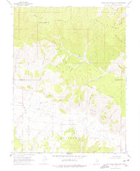
1969 Map of Minnie Maud Creek West
USGS Topo · Published 1978About this map
Roan Cliffs dominate this high-desert landscape on the border of Duchesne and Carbon counties, rising above the canyon systems of the Uinta Basin. The drainage of Minnie Maud Creek carves a deep valley between Argyle Ridge and Minnie Maud Ridge, defining the local topography. This 1969 field-checked survey highlights the traditional land-use patterns of the era, marked by features such as Orson Bedground and the Warren Trail. In the southern portion of the map, the high plateau opens into Whitmore Park and Emma Park, separated by the Brook Meadow area. The network of jeep trails and canyons, including Maynard Canyon and Jack Canyon, illustrates the remote and utilitarian character of this region before modern infrastructure changes, providing a clear record of the watershed and ranching access points during the late 1960s.
Find a feature on this map
31 named features on this map. Tap any name to fly to it.
Don’t see what you’re looking for? This feature index may not catch every label — zoom into the map to look around manually.
Map Details
Editions of this 1969 Minnie Maud Creek West Map
2 editions found
Other maps of this area

1886 · Price River
USGS Topo · 1:250,000

1896 · Price River
USGS Topo · 1:250,000

1914 · Castle Gate
USGS Topo · 1:62,500

1915 · Wellington
USGS Topo · 1:62,500

1916 · Castle Gate
USGS Topo · 1:62,500

1956 · Price
USGS Topo · 1:250,000

1960 · Price
USGS Topo · 1:250,000

1962 · Price
USGS Topo · 1:250,000
1968 · Lance Canyon
USGS Topo · 1:24,000
1968 · Jones Hollow
USGS Topo · 1:24,000