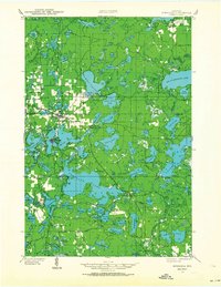
1938 Map of Minocqua
USGS Topo · Published 1964About this map
Minocqua and Woodruff anchor this 1938 look at Wisconsin's Northwoods, where the transition from timber extraction to a recreational economy is evident. The landscape is dominated by glacial water bodies, from the sprawling Big St Germain Lake to the complex chain of lakes surrounding the Minocqua Country Club. Transportation networks define the era, with the Chicago Milwaukee ST Paul And Pacific and Chicago And Northwestern railroads cutting through the timberland. Local education is decentralized, evidenced by isolated country schoolhouses like Hall Sch and Faulkner Sch. The presence of the Lake Tomahawk Fire Tower and Muskellunge Fire Tower highlights the period's active forest fire surveillance, while the State Farm and Plum Lake Golf Course near Sayner show the diverse land use as the region became a premier destination for seasonal camps and sportsmen.
Find a feature on this map
137 named features on this map. Tap any name to fly to it.
Don’t see what you’re looking for? This feature index may not catch every label — zoom into the map to look around manually.
Map Details
Editions of this 1938 Minocqua Map
2 editions found
Other maps of this area

1930 · Robbins
USGS Topo · 1:48,000

1938 · Minocqua
USGS Topo · 1:48,000

1938 · Robbins
USGS Topo · 1:48,000

1938 · Lac Du Flambeau
USGS Topo · 1:48,000

1939 · Trout Lake
USGS Topo · 1:48,000

1939 · Lac Du Flambeau
USGS Topo · 1:48,000

1939 · Mc Cord
USGS Topo · 1:48,000

1939 · Winchester
USGS Topo · 1:48,000

1939 · Cassian
USGS Topo · 1:48,000

1940 · Rhinelander
USGS Topo · 1:48,000