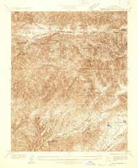
1932 Map of Mint Canyon
USGS Topo · Published 1932About this map
Angeles National Forest dominates this 1932 survey, showing a landscape on the verge of significant infrastructure changes. The northern portion of the map highlights the Bouquet Canyon Dam and its proposed reservoir, with dashed lines indicating the future shoreline that would soon alter the geography of Bouquet Canyon. This era of development is further evidenced by Bouquet Canyon Road, which was being carved through the hills to support the new waterworks.
Find a feature on this map
29 named features on this map. Tap any name to fly to it.
Don’t see what you’re looking for? This feature index may not catch every label — zoom into the map to look around manually.
Map Details
Editions of this 1932 Mint Canyon Map
This is the sole edition of this map. No revisions or reprints were ever made.
Other maps of this area

1900 · Fernando
USGS Topo · 1:62,500

1901 · Southern California Sheet No. 1
USGS Topo · 1:250,000

1904 · Southern California Sheet No. 1
USGS Topo · 1:250,000

1915 · Elizabeth Lake
USGS Topo · 1:125,000

1917 · Elizabeth Lake
USGS Topo · 1:125,000

1929 · Lang
USGS Topo · 1:24,000

1930 · Ravenna
USGS Topo · 1:24,000

1931 · Del Sur
USGS Topo · 1:24,000
1932 · La Brun
USGS Topo · 1:24,000

1932 · Red Rover
USGS Topo · 1:24,000