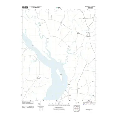
2010 Map of Mintonsville
USGS Topo · Published 2010About this map
The Chowan River dominates this corner of Gates County, defining a landscape shaped by river landings and coastal plain agriculture. Historical transportation points like Cannon Ferry and Woodleys Wharf mark the eastern bank, reflecting a time when the waterway served as a primary artery for local commerce. To the west, the landscape transitions into the wet reaches of Deep Swamp Branch and the Taylor Millpond. The map reveals a dense network of inland named corners and crossroads, such as Mintonsville, Mitchells Fork, and Old Chapel Crossroads. These settlements are connected by rural routes like Indian Neck Rd and Cannons Ferry Rd, tracing the legacy of family holdings and community hubs in this rural North Carolina region. Landings including Roberts Landing, Bond Landing, and Oldtown Landing emphasize the historic reliance on the river for movement and trade.
Find a feature on this map
52 named features on this map. Tap any name to fly to it.
Don’t see what you’re looking for? This feature index may not catch every label — zoom into the map to look around manually.
Map Details
Editions of this 2010 Mintonsville Map
This is the sole edition of this map. No revisions or reprints were ever made.
Other maps of this area

1904 · Edenton
USGS Topo · 1:62,500

1906 · Beckford
USGS Topo · 1:48,000

1907 · Beckford
USGS Topo · 1:62,500

1908 · Winton
USGS Topo · 1:62,500

1940 · Beckford
USGS Topo · 1:62,500

1942 · Edenton
USGS Topo · 1:62,500

1943 · Edenton
USGS Topo · 1:62,500

1953 · Norfolk
USGS Topo · 1:250,000
1981 · Merchants Millpond
USGS Topo · 1:24,000
1981 · Gatesville
USGS Topo · 1:24,000