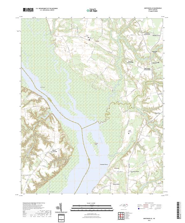
2022 Map of Mintonsville
USGS Topo · Published 2022About this map
The Chowan River serves as the dominant geographical feature of this landscape, carving a wide path through the borderlands of Gates, Hertford, and Chowan Counties. The river's influence is evident in the cluster of aquatic and marshy landmarks such as Holiday Island and the sprawling Honey Pot Swamp to the north. Settlement patterns are defined by historic intersections and family holdings, with numerous crossroads communities including Mintonsville, Mitchells Fork, and Old Chapel Crossroads providing anchors for the rural population.
Find a feature on this map
68 named features on this map. Tap any name to fly to it.
Don’t see what you’re looking for? This feature index may not catch every label — zoom into the map to look around manually.
Map Details
Editions of this 2022 Mintonsville Map
This is the sole edition of this map. No revisions or reprints were ever made.
Other maps of this area

1904 · Edenton
USGS Topo · 1:62,500

1906 · Beckford
USGS Topo · 1:48,000

1907 · Beckford
USGS Topo · 1:62,500

1908 · Winton
USGS Topo · 1:62,500

1940 · Beckford
USGS Topo · 1:62,500

1942 · Edenton
USGS Topo · 1:62,500

1943 · Edenton
USGS Topo · 1:62,500

1953 · Norfolk
USGS Topo · 1:250,000
1981 · Merchants Millpond
USGS Topo · 1:24,000
1981 · Gatesville
USGS Topo · 1:24,000