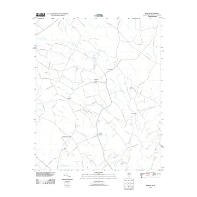
2011 Map of Minturn
USGS Topo · Published 2011About this map
The Little Pee Dee River and the extensive wetlands of Sweat Swamp dominate this rural landscape on the South Carolina and North Carolina border. Small farming settlements and crossroads such as Minturn, Carolina, and Sinclair Crossroads are connected by a network of local roads often named for resident families, such as Jack McIntyre Rd and D J McLaurin Rd. Historically significant sites like the Carolina Presbyterian Church Cemetery and Fairview Church Cemetery point to the deep-rooted community foundations in this area. Movement across the river and its numerous tributaries, including Martins Branch and Carolina Branch, is facilitated by local landmarks like McInnis Bridge and McKays Bridge. The map also documents modern water management features like the Hamer Pond Dam D-3595, illustrating the ongoing interaction between the local population and the low-lying terrain of the coastal plain.
Find a feature on this map
87 named features on this map. Tap any name to fly to it.
Don’t see what you’re looking for? This feature index may not catch every label — zoom into the map to look around manually.
Map Details
Editions of this 2011 Minturn Map
This is the sole edition of this map. No revisions or reprints were ever made.
Other maps of this area

1942 · Rockingham
USGS Topo · 1:125,000

1943 · Gum Swamp
USGS Topo · 1:62,500

1953 · Florence
USGS Topo · 1:250,000

1954 · Florence
USGS Topo · 1:250,000

1960 · Dillon East
USGS Topo · 1:24,000

1960 · Dillon West
USGS Topo · 1:24,000

1971 · Minturn
USGS Topo · 1:24,000

1971 · Johns
USGS Topo · 1:24,000

1972 · Clio
USGS Topo · 1:24,000
1972 · Mc Coll
USGS Topo · 1:24,000