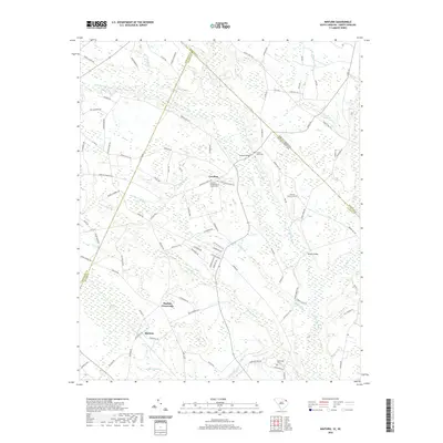
2020 Map of Minturn
USGS Topo · Published 2020About this map
Little Pee Dee River meanders across this landscape, defining the rural geography where the borders of Dillon and Marlboro Counties in South Carolina meet Robeson County, North Carolina. The settlement at Carolina serves as a local focal point, anchored by the Carolina Presbyterian Church and its adjacent Carolina Church Cem. The road network connects small crossroads communities like Sinclair Crossroads and Minturn, following a pattern of long-established family routes and farm-to-market roads such as Parrish Mill Rd and Ivey Cemetery Rd. Significant wetland features including Sweat Swamp and the elliptical depression of Donohoe Bay dominate the southwestern quadrant. These swampy lowlands are crossed by historic spans like McInnis Bridge and McKays Bridge, illustrating how early infrastructure was adapted to the region’s complex hydrography of creeks and branches.
Find a feature on this map
97 named features on this map. Tap any name to fly to it.
Don’t see what you’re looking for? This feature index may not catch every label — zoom into the map to look around manually.
Map Details
Editions of this 2020 Minturn Map
This is the sole edition of this map. No revisions or reprints were ever made.
Other maps of this area

1942 · Rockingham
USGS Topo · 1:125,000

1943 · Gum Swamp
USGS Topo · 1:62,500

1953 · Florence
USGS Topo · 1:250,000

1954 · Florence
USGS Topo · 1:250,000

1960 · Dillon East
USGS Topo · 1:24,000

1960 · Dillon West
USGS Topo · 1:24,000

1971 · Minturn
USGS Topo · 1:24,000

1971 · Johns
USGS Topo · 1:24,000

1972 · Clio
USGS Topo · 1:24,000
1972 · Mc Coll
USGS Topo · 1:24,000