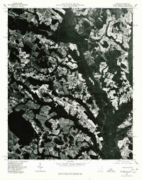
1976 Map of Minturn
USGS Topo · Published 1978About this map
The Little Pee Dee River winds through this 1976 orthophoto, defining a landscape of dense bottomland timber and a mosaic of angular agricultural clearings. This aerial perspective, captured by the U.S. Geological Survey, shows the rural character of the borderlands between North and South Carolina. The settlement of Minturn and the junction at Crossroads anchor the local road network, which includes Route 57 and Route 83. Unlike a traditional topographic line drawing, this photographic record reveals the exact texture of the fields and forest canopies as they existed during the mid-1970s. The interplay of dark river swamps and bright, tilled land illustrates the long-standing agricultural dependence on the well-drained soils found adjacent to the river’s floodplains.
Find a feature on this map
6 named features on this map. Tap any name to fly to it.
Don’t see what you’re looking for? This feature index may not catch every label — zoom into the map to look around manually.
Map Details
Editions of this 1976 Minturn Map
This is the sole edition of this map. No revisions or reprints were ever made.
Other maps of this area

1942 · Rockingham
USGS Topo · 1:125,000

1943 · Gum Swamp
USGS Topo · 1:62,500

1953 · Florence
USGS Topo · 1:250,000

1954 · Florence
USGS Topo · 1:250,000

1960 · Dillon East
USGS Topo · 1:24,000

1960 · Dillon West
USGS Topo · 1:24,000

1971 · Minturn
USGS Topo · 1:24,000

1971 · Johns
USGS Topo · 1:24,000

1972 · Clio
USGS Topo · 1:24,000
1972 · Mc Coll
USGS Topo · 1:24,000