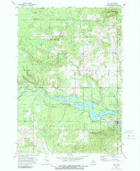
1972 Map of Mio
USGS Topo · Published 1989About this map
The Au Sable River carves a deep valley through this northern Michigan landscape, where the waters are held by the Mio Dam Pond. This 1970s era documentation reveals a community shaped by the river and the surrounding Oscoda State Forest and Huron National Forest. The settlement of Mio serves as a local hub, featuring the Mio Au Sable Sch and a local Drive-in Theater along the highway. Outside the main town, the map tracks several smaller named locales including Biggs Settlement, Sherwood Corners, and Red Oak. Genealogists may find particular value in the location of Township No 1 Cem (Muskrat Lake Cem) near the northern border. The terrain is dotted with aviation landmarks, from the Mio Airport to the Lost Creek Sky Ranch Airport, indicating the region's importance for forest management and recreational access.
Find a feature on this map
38 named features on this map. Tap any name to fly to it.
Don’t see what you’re looking for? This feature index may not catch every label — zoom into the map to look around manually.
Map Details
Editions of this 1972 Mio Map
2 editions found
Other maps of this area

1949 · Lewiston
USGS Topo · 1:62,500

1950 · Comstock Hills
USGS Topo · 1:24,000

1951 · Comstock Hills
USGS Topo · 1:24,000

1954 · Traverse City
USGS Topo · 1:250,000

1955 · Comins
USGS Topo · 1:62,500

1958 · Traverse City
USGS Topo · 1:250,000

1963 · Luzerne
USGS Topo · 1:24,000

1963 · Red Oak
USGS Topo · 1:24,000

1972 · Mio
USGS Topo · 1:24,000

1972 · Mack Lake
USGS Topo · 1:24,000