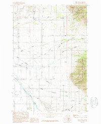
1987 Map of Miser Creek
USGS Topo · Published 1988About this map
The foothills of the Bridger Range define the eastern edge of this landscape, where steep slopes descend into a network of creek drainages feeding the East Gallatin River. This late-1980s provisional survey shows a rural environment transitioning from the mountain canyons to the agricultural valley floor. Small clusters of activity are noted at Reese, Ross, and Limestone, while the Springhill Hill Sch and a local Cem serve as significant markers of the area's social history.
Find a feature on this map
35 named features on this map. Tap any name to fly to it.
Don’t see what you’re looking for? This feature index may not catch every label — zoom into the map to look around manually.
Map Details
Editions of this 1987 Miser Creek Map
This is the sole edition of this map. No revisions or reprints were ever made.
Other maps of this area

1888 · Three Forks
USGS Topo · 1:250,000

1891 · Livingston
USGS Topo · 1:250,000

1893 · Livingston
USGS Topo · 1:250,000

1894 · Three Forks
USGS Topo · 1:250,000

1895 · Three Forks
USGS Topo · 1:250,000

1947 · Bozeman
USGS Topo · 1:250,000

1948 · Bozeman
USGS Topo · 1:250,000

1950 · Belgrade
USGS Topo · 1:62,500

1951 · Bozeman Pass
USGS Topo · 1:62,500

1951 · Sedan
USGS Topo · 1:62,500