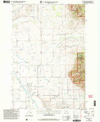
2000 Map of Miser Creek
USGS Topo · Published 2005About this map
The Gallatin River flows through the southwestern corner of this Gallatin County landscape, which transitions from irrigated valley floors to the steep, wooded slopes of the Bridger Range. In the early 2000s, the rural character of the region is defined by scattered storage bins and the persistent infrastructure of the Mc Guire Ditch. The small settlement of Camona sits near the river, while to the north, the Springhill Sch and a local Cem serve the surrounding ranching and farming community. Much of the eastern portion of the sheet is managed by the Bozeman Ranger District within the Gallatin National Forest. This terrain is dissected by numerous drainages, including Miser Creek and Bostwick Creek, which have carved significant features like Bostwick Canyon. The map reveals a land defined by its water rights and the interface between agricultural valley life and the protected forest highlands.
Find a feature on this map
34 named features on this map. Tap any name to fly to it.
Don’t see what you’re looking for? This feature index may not catch every label — zoom into the map to look around manually.
Map Details
Editions of this 2000 Miser Creek Map
This is the sole edition of this map. No revisions or reprints were ever made.
Other maps of this area

1888 · Three Forks
USGS Topo · 1:250,000

1891 · Livingston
USGS Topo · 1:250,000

1893 · Livingston
USGS Topo · 1:250,000

1894 · Three Forks
USGS Topo · 1:250,000

1895 · Three Forks
USGS Topo · 1:250,000

1947 · Bozeman
USGS Topo · 1:250,000

1948 · Bozeman
USGS Topo · 1:250,000

1950 · Belgrade
USGS Topo · 1:62,500

1951 · Bozeman Pass
USGS Topo · 1:62,500

1951 · Sedan
USGS Topo · 1:62,500