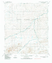
1984 Map of Misheguk Mountain D-1
USGS Topo · Published 1984About this map
The Colville River and its northern tributaries dominate this Arctic landscape within the expansive National Petroleum Reserve in Alaska. This 1984 edition, based on aerial photography from the mid-1970s, captures a region defined by complex hydrology and isolated terrain features. Significant watercourses including Reynard Creek, Nuka River, and the winding Singayoak Creek provide the primary geographical structure. Near the confluence of several streams, a solitary Tractor Trail cuts across the tundra, marking one of the few human imprints in this wilderness. Local topography is highlighted by named heights such as Nuka and the small collection of Migrant Lakes in the southeastern quadrant. The map serves as a detailed record of the drainage patterns of Sorepaw Creek and other waterways that feed the region's vast watershed before further resource exploration altered the landscape.
Find a feature on this map
9 named features on this map. Tap any name to fly to it.
Don’t see what you’re looking for? This feature index may not catch every label — zoom into the map to look around manually.
Map Details
Editions of this 1984 Misheguk Mountain D-1 Map
This is the sole edition of this map. No revisions or reprints were ever made.
Other maps of this area

1951 · Utukok River
USGS Topo · 1:250,000

1951 · Lookout Ridge
USGS Topo · 1:250,000

1951 · Howard Pass
USGS Topo · 1:250,000

1951 · Misheguk Mountain
USGS Topo · 1:250,000

1956 · Lookout Ridge
USGS Topo · 1:250,000

1956 · Howard Pass
USGS Topo · 1:250,000

1956 · Misheguk Mountain
USGS Topo · 1:250,000

1956 · Utukok River
USGS Topo · 1:250,000

1965 · Utukok River
USGS Topo · 1:250,000
1984 · Misheguk Mountain C-1
USGS Topo · 1:63,360