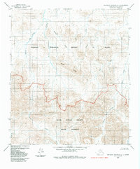
1984 Map of Misheguk Mountain C-1
USGS Topo · Published 1984About this map
Noatak National Preserve and the National Petroleum Reserve in Alaska meet in this 1980s landscape, defined by the administrative boundaries established by the Alaska National Interest Lands Conservation Act. The map captures a transition between the protected Noatak Wilderness to the south and the petroleum reserve to the north. Centered on the prominent Nuka Ridge, the area is etched by an intricate network of drainage systems, including Singayoak Creek, Suvaloyuk Creek, and the curiously named Sorepaw Creek.
Find a feature on this map
14 named features on this map. Tap any name to fly to it.
Don’t see what you’re looking for? This feature index may not catch every label — zoom into the map to look around manually.
Map Details
Editions of this 1984 Misheguk Mountain C-1 Map
This is the sole edition of this map. No revisions or reprints were ever made.
Other maps of this area

1951 · Howard Pass
USGS Topo · 1:250,000

1951 · Misheguk Mountain
USGS Topo · 1:250,000

1956 · Howard Pass
USGS Topo · 1:250,000

1956 · Misheguk Mountain
USGS Topo · 1:250,000
1984 · Howard Pass D-5
USGS Topo · 1:63,360
1984 · Misheguk Mountain C-2
USGS Topo · 1:63,360
1984 · Misheguk Mountain D-1
USGS Topo · 1:63,360
1984 · Howard Pass C-5
USGS Topo · 1:63,360
1984 · Howard Pass B-5
USGS Topo · 1:63,360
1984 · Misheguk Mountain D-2
USGS Topo · 1:63,360