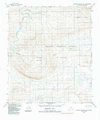
1984 Map of Misheguk Mountain D-5
USGS Topo · Published 1984About this map
The Kokolik River winds through the northwestern corner of this remote North Slope landscape, which falls entirely within the National Petroleum Reserve in Alaska. Dominating the central topography is Tupikchak Mountain, surrounded by a complex network of drainage systems. Streams such as Shulunaruak Creek, Tupikchak Creek, and Plunge Creek define the local watershed, radiating from the higher elevations of the Misheguk Mountain range.
Find a feature on this map
9 named features on this map. Tap any name to fly to it.
Don’t see what you’re looking for? This feature index may not catch every label — zoom into the map to look around manually.
Map Details
Editions of this 1984 Misheguk Mountain D-5 Map
This is the sole edition of this map. No revisions or reprints were ever made.
Other maps of this area

1951 · De Long Mountains
USGS Topo · 1:250,000

1951 · Utukok River
USGS Topo · 1:250,000

1951 · Point Lay
USGS Topo · 1:250,000

1951 · Misheguk Mountain
USGS Topo · 1:250,000

1955 · De Long Mountains
USGS Topo · 1:250,000

1955 · Point Lay
USGS Topo · 1:250,000
1955 · Utukok River A-5
USGS Topo · 1:63,360
1955 · Utukok River A-4
USGS Topo · 1:63,360

1955 · Point Lay A-1
USGS Topo · 1:63,360
1955 · De Long Mountains D-1
USGS Topo · 1:63,360