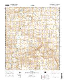
2015 Map of Misheguk Mountain D-5 NW
USGS Topo · Published 2015About this map
Kokolik River winds through this northern landscape, providing a primary hydrological corridor through the North Slope. The drainage patterns of Kantangnak Cr and Shulakpaurak Cr converge in this sector, defining the low-lying relief between the township boundaries of t55 r42w and t6s r41w. This 2015 survey reflects the enduring geography of the Arctic wilderness, where the land is primarily characterized by its watercourses rather than human settlements or infrastructure. The absence of roads or developed landmarks underscores the isolation of this region within the North Slope Borough, where the natural flow of the Kokolik River remains the most significant geographic feature for navigation and environmental study.
Find a feature on this map
7 named features on this map. Tap any name to fly to it.
Don’t see what you’re looking for? This feature index may not catch every label — zoom into the map to look around manually.
Map Details
Editions of this 2015 Misheguk Mountain D-5 NW Map
This is the sole edition of this map. No revisions or reprints were ever made.
Other maps of this area

1951 · De Long Mountains
USGS Topo · 1:250,000

1951 · Utukok River
USGS Topo · 1:250,000

1951 · Point Lay
USGS Topo · 1:250,000

1951 · Misheguk Mountain
USGS Topo · 1:250,000

1955 · De Long Mountains
USGS Topo · 1:250,000

1955 · Point Lay
USGS Topo · 1:250,000
1955 · Utukok River A-5
USGS Topo · 1:63,360

1955 · Point Lay A-1
USGS Topo · 1:63,360
1955 · De Long Mountains D-1
USGS Topo · 1:63,360

1956 · Misheguk Mountain
USGS Topo · 1:250,000