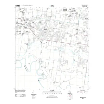
2010 Map of Mission
USGS Topo · Published 2010About this map
The Rio Grande serves as the southern boundary of this landscape, winding past a series of named riverfront land divisions known as bancos, including Anzaldua Banco Number 45 and Granjeno Banco Number Forty-Four. This area south of Mission reflects a deep agricultural and cultural history, anchored by the La Lomita Historic District and the adjacent La Lomita Farm. The terrain is characterized by a complex network of irrigation infrastructure, notably the Mission Main Canal and Edinburg Main Canal, which support the region's intensive citrus and produce cultivation.
Find a feature on this map
103 named features on this map. Tap any name to fly to it.
Don’t see what you’re looking for? This feature index may not catch every label — zoom into the map to look around manually.
Map Details
Editions of this 2010 Mission Map
This is the sole edition of this map. No revisions or reprints were ever made.
Other maps of this area

1914 · San Juan
USGS Topo · 1:48,000

1916 · San Juan
USGS Topo · 1:62,500

1940 · Monte Christo
USGS Topo · 1:62,500

1949 · Mc Allen
USGS Topo · 1:250,000

1954 · McAllen
USGS Topo · 1:250,000

1957 · Mc Allen
USGS Topo · 1:250,000

1962 · McAllen
USGS Topo · 1:250,000
1962 · Las Milpas
USGS Topo · 1:24,000

1963 · La Joya
USGS Topo · 1:24,000

1963 · Edinburg
USGS Topo · 1:24,000