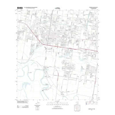
2013 Map of Mission
USGS Topo · Published 2013About this map
The Rio Grande creates a winding southern boundary for this portion of Hidalgo County, where international commerce and agricultural history meet. The landscape is defined by its complex water management system, including the Edinburg Main Canal and Mission Main Canal, alongside natural features like the Sardinas Resaca. Cultural heritage is anchored by the La Lomita Historic District and La Lomita Farm near the river, while the Lomita Boulevard Commercial District reflects the area's modern economic development. Residential clusters such as Sharyland, Madero, and Granjeno are interspersed with significant local landmarks including Laurel Hill Cem and Valley Memorial Gardens. The map also details several unique riverine land features known as bancos, such as Tortuga Banco Number 65 and Anzaldua Banco Number 45, which highlight the historical shifts in the river's course over time.
Find a feature on this map
52 named features on this map. Tap any name to fly to it.
Don’t see what you’re looking for? This feature index may not catch every label — zoom into the map to look around manually.
Map Details
Editions of this 2013 Mission Map
This is the sole edition of this map. No revisions or reprints were ever made.
Other maps of this area

1914 · San Juan
USGS Topo · 1:48,000

1916 · San Juan
USGS Topo · 1:62,500

1940 · Monte Christo
USGS Topo · 1:62,500

1949 · Mc Allen
USGS Topo · 1:250,000

1954 · McAllen
USGS Topo · 1:250,000

1957 · Mc Allen
USGS Topo · 1:250,000

1962 · McAllen
USGS Topo · 1:250,000
1962 · Las Milpas
USGS Topo · 1:24,000

1963 · La Joya
USGS Topo · 1:24,000

1963 · Edinburg
USGS Topo · 1:24,000