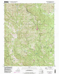
1996 Map of Mississippi Creek
USGS Topo · Published 1998About this map
Henry W Coe State Park dominates this topography along the border of Stanislaus and Santa Clara counties. The landscape is defined by the complex drainage systems of the East Fork Coyote Creek and the Middle Fork Coyote Creek, which cut deep canyons through the Diablo Range. High points like Bear Mtn overlook a network of 4wd tracks that provide the only access into the interior. Significant water features such as Hoover Lake and Mississippi Creek are captured alongside small highland clearings like Paradise Flat. The presence of the Radio Relay Sta and several established campsites, including Poverty Flat and Manzanita Point, indicates the park's transition into a managed wilderness area during the late twentieth century.
Find a feature on this map
41 named features on this map. Tap any name to fly to it.
Don’t see what you’re looking for? This feature index may not catch every label — zoom into the map to look around manually.
Map Details
Editions of this 1996 Mississippi Creek Map
This is the sole edition of this map. No revisions or reprints were ever made.
Other maps of this area

1897 · Mt. Hamilton
USGS Topo · 1:62,500

1917 · Morgan Hill
USGS Topo · 1:62,500

1921 · Gilroy Hot Springs
USGS Topo · 1:62,500

1938 · Mt. Boardman
USGS Topo · 1:62,500

1939 · Morgan Hill
USGS Topo · 1:62,500

1939 · Gilroy Hot Springs
USGS Topo · 1:62,500

1940 · Gilroy Hot Springs
USGS Topo · 1:62,500

1941 · Morgan Hill
USGS Topo · 1:62,500

1942 · Mt. Hamilton
USGS Topo · 1:62,500

1942 · Mt. Boardman
USGS Topo · 1:62,500