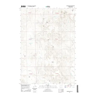
2015 Map of Missouri Buttes
USGS Topo · Published 2015About this map
Missouri Buttes dominate the northeastern landscape of this Crook County quadrangle, situated just north of the Belle Fourche River. The terrain is defined by a series of dramatic geographic features, from the deep recess of Hell Hole to the prominent heights of Cedar Hill. Ranching and land management are evident through the network of drainage-oriented reservoirs like Basin Number 1 Reservoir and Basin Reservoir Number 2. Local infrastructure is concentrated along unpaved routes such as Lake Ranch Rd and Cabin Creek Rd, which traverse the complex topography of the Weehinkle Divide and Sawmill Canyon. The map provides a detailed look at the hydrology of the area, including Missouri Buttes Lake and the various draws and canyons that feed into the larger river system to the south.
Find a feature on this map
35 named features on this map. Tap any name to fly to it.
Don’t see what you’re looking for? This feature index may not catch every label — zoom into the map to look around manually.
Map Details
Editions of this 2015 Missouri Buttes Map
This is the sole edition of this map. No revisions or reprints were ever made.
Other maps of this area

1905 · Devils Tower
USGS Topo · 1:125,000

1918 · Moorcroft
USGS Topo · 1:125,000

1918 · Moorcroft
USGS Topo · 1:62,500

1954 · Sunny Divide
USGS Topo · 1:24,000

1954 · Storm Hill
USGS Topo · 1:24,000

1954 · Carlile
USGS Topo · 1:24,000

1954 · Missouri Buttes
USGS Topo · 1:24,000

1954 · Gillette
USGS Topo · 1:250,000

1955 · Devils Tower
USGS Topo · 1:62,500

1955 · Gillette
USGS Topo · 1:250,000