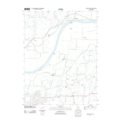
2012 Map of Missouri City
USGS Topo · Published 2012About this map
The Missouri River defines the geography of this quadrangle, its sweeping curves creating distinct landforms like Missouri City Bend and Jackson Bend. On the northern bank, Missouri City and the elevated terrain of Nebo Hill look across the floodplain toward the river-bottom settlements of Atherton and Eton. The landscape transitions from the river valley to the rolling uplands of Jackson County, where a legacy of early Missouri settlement is visible through a high concentration of family and community burial grounds, including Keller Cemetery, Franklin Cemetery, and Rice Cemetery. Along the banks of the Little Blue River, the site of Blue Mills and nearby Camp Santa Fe Trail reflect the area's deep connection to historic western migration and trade routes. To the south, modern infrastructure like the Liberty Landing Airport and the community of Ripley represent the continuing growth of the Independence area.
Find a feature on this map
102 named features on this map. Tap any name to fly to it.
Don’t see what you’re looking for? This feature index may not catch every label — zoom into the map to look around manually.
Map Details
Editions of this 2012 Missouri City Map
This is the sole edition of this map. No revisions or reprints were ever made.
Other maps of this area

1894 · Independence
USGS Topo · 1:125,000

1933 · Blue Springs
USGS Topo · 1:24,000

1934 · Oak Grove
USGS Topo · 1:24,000

1934 · Independence
USGS Topo · 1:24,000

1935 · Buckner
USGS Topo · 1:24,000

1935 · Missouri City
USGS Topo · 1:24,000

1935 · Liberty
USGS Topo · 1:24,000

1936 · Kearney
USGS Topo · 1:48,000

1940 · Liberty
USGS Topo · 1:31,680
1940 · Independence
USGS Topo · 1:31,680