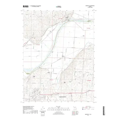
2017 Map of Missouri City
USGS Topo · Published 2017About this map
Missouri City sits prominently along the north bank of the Missouri River, where the City Bend and Jackson Bend define the waterway's winding path through the borderlands of Clay and Jackson Counties. This modern survey illustrates a landscape of established river towns and rural outskirts, notably featuring Liberty Landing on the northern shore. Further south, the terrain rises into the hills surrounding Independence, where the residential growth of Sugar Creek and Ripley meets the valleys of the Little Blue River and Sugar Creek.
Find a feature on this map
74 named features on this map. Tap any name to fly to it.
Don’t see what you’re looking for? This feature index may not catch every label — zoom into the map to look around manually.
Map Details
Editions of this 2017 Missouri City Map
This is the sole edition of this map. No revisions or reprints were ever made.
Other maps of this area

1894 · Independence
USGS Topo · 1:125,000

1933 · Blue Springs
USGS Topo · 1:24,000

1934 · Oak Grove
USGS Topo · 1:24,000

1934 · Independence
USGS Topo · 1:24,000

1935 · Buckner
USGS Topo · 1:24,000

1935 · Missouri City
USGS Topo · 1:24,000

1935 · Liberty
USGS Topo · 1:24,000

1936 · Kearney
USGS Topo · 1:48,000

1940 · Liberty
USGS Topo · 1:31,680
1940 · Independence
USGS Topo · 1:31,680