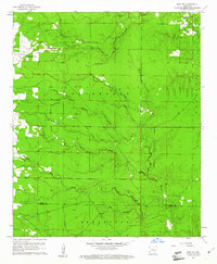
1960 Map of Mist NW
USGS Topo · Published 1961About this map
Bearhouse Creek and its many tributaries, including Miller Creek, define the landscape of this rural Arkansas territory at the start of the 1960s. The map illustrates a primarily agricultural and timbered region where community life centered around small country churches and family burial grounds. Notable landmarks for local history include Pleasant Grove Ch in the west and Center Point Ch near the northern boundary. The intricate network of waterways like Wolf Creek, Lost Creek, and Holley Creek dictates the placement of the sparse road system. Along the southern edge, the border between Drew and Ashley counties is clearly delineated, crossing through the winding path of Haw Branch. Genealogists may find value in the specific locations of Jordan Cem, Cotham Cem, and Judkins Cem, which serve as quiet markers of the area's early settlement families.
Find a feature on this map
20 named features on this map. Tap any name to fly to it.
Don’t see what you’re looking for? This feature index may not catch every label — zoom into the map to look around manually.
Map Details
Editions of this 1960 Mist NW Map
2 editions found
Other maps of this area

1935 · Mist
USGS Topo · 1:62,500

1935 · Cominto
USGS Topo · 1:62,500

1952 · Fountain Hill
USGS Topo · 1:24,000

1953 · Greenwood
USGS Topo · 1:250,000

1956 · Greenwood
USGS Topo · 1:250,000

1960 · Snyder
USGS Topo · 1:24,000

1960 · Mist
USGS Topo · 1:62,500

1960 · Collins
USGS Topo · 1:24,000

1960 · Collins
USGS Topo · 1:62,500
1960 · Line
USGS Topo · 1:24,000