
1899 Map of Mitchell
USGS Topo · Published 1926About this map
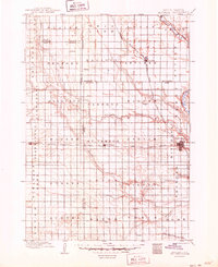
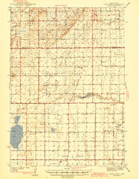
Mitchell stands as a primary hub of settlement and transportation in this late nineteenth-century landscape, situated where the James River Division of the railroad meets the Iowa and Dakota Division. The terrain is defined by the winding course of the James River to the east and the significant drainage systems of Firesteel Creek and Enemy Creek which cut across the prairie townships. This survey illustrates the early grid-style organization of the region, revealing a network of rural post offices and small rail stops such as Mt. Vernon, Plankinton, and Letcher. Detailed township divisions like Palatine, Beulah, and Lisbon provide a clear view of the area's development before modern infrastructure altered the agrarian patterns. Researchers can find several smaller, namesake settlements including Storla, Amboy, and Stover positioned along county lines and secondary wagon roads.
Find a feature on this map
52 named features on this map. Tap any name to fly to it.
Don’t see what you’re looking for? This feature index may not catch every label — zoom into the map to look around manually.
Map Details
Editions of this 1899 Mitchell Map
3 editions found
Other maps of this area

1898 · Olivet
USGS Topo · 1:125,000

1898 · Huron
USGS Topo · 1:125,000

1899 · Mitchell
USGS Topo · 1:125,000

1899 · Alexandria
USGS Topo · 1:125,000

1899 · De Smet
USGS Topo · 1:125,000
1942 · Crow Lake
USGS Topo · 1:62,500

1953 · Huron
USGS Topo · 1:250,000

1953 · Watertown
USGS Topo · 1:250,000

1954 · Huron
USGS Topo · 1:250,000

1955 · Sioux Falls
USGS Topo · 1:250,000
Featured Places
- Mitchell, SD
- Plankinton, Plankinton Township
- Mount Vernon, Mount Vernon Township
- Stickney, Dudley Township
- Letcher, Letcher Township