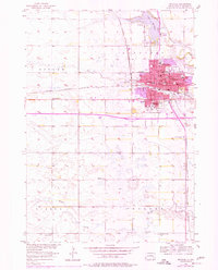
1957 Map of Mitchell
USGS Topo · Published 1977About this map
Mitchell serves as the focal point of this mid-century survey, revealing a landscape defined by the convergence of the Chicago Milwaukee St Paul and Pacific rail lines and the waters of Lake Mitchell. As a regional hub in Davison County, the town's civic and educational character is marked by the presence of Dakota Wesleyan University, the Corn Palace, and several neighborhood schools including Notre Dame Sch and Whittier Sch. The surrounding townships of Beulah and Lisbon maintain a rural character, where small rural education centers like French Sch and School No 5 dot the terrain near Enemy Creek. This era captures the city's expansion prior to later interstate developments, highlighting the original street grid from Havens St to the southern outskirts near Sunset Memorial Park. The map provides a look at local industry through numerous Gravel Pits and the essential infrastructure of the Waterworks near Firesteel Creek.
Find a feature on this map
48 named features on this map. Tap any name to fly to it.
Don’t see what you’re looking for? This feature index may not catch every label — zoom into the map to look around manually.
Map Details
Editions of this 1957 Mitchell Map
2 editions found
Other maps of this area

1899 · Mitchell
USGS Topo · 1:125,000

1899 · Alexandria
USGS Topo · 1:125,000

1955 · Sioux Falls
USGS Topo · 1:250,000

1955 · Mitchell
USGS Topo · 1:250,000

1957 · Ethan
USGS Topo · 1:24,000

1957 · Loomis
USGS Topo · 1:24,000

1957 · Riverside
USGS Topo · 1:24,000

1957 · Farwell
USGS Topo · 1:24,000

1957 · Mitchell
USGS Topo · 1:24,000

1958 · Sioux Falls
USGS Topo · 1:250,000