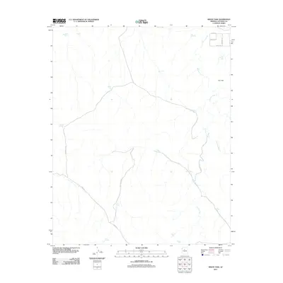
2011 Map of Mixon Tank
USGS Topo · Published 2011About this map
Cataract Creek and Red Lake Wash define the drainage patterns of this high-altitude landscape in northern Arizona. The area is dominated by ranching infrastructure, characterized by a series of named water tanks essential for livestock management in this arid environment. Key water sources include Mixon Tank, Big Tank, and the curiously named Robber Tank. The road network reflects recent residential or ranch development in the northeast near Four Hills, with named thoroughfares like Sunaire Ave and Westwind Rd. In the southern portion of the quadrangle, more primitive routes such as Espee Rd and W High Butte Dr provide access to remote landmarks like Chimney Tank and Pipline Tank.
Find a feature on this map
25 named features on this map. Tap any name to fly to it.
Don’t see what you’re looking for? This feature index may not catch every label — zoom into the map to look around manually.
Map Details
Editions of this 2011 Mixon Tank Map
This is the sole edition of this map. No revisions or reprints were ever made.
Other maps of this area

1886 · Chino
USGS Topo · 1:250,000

1891 · Chino
USGS Topo · 1:250,000

1922 · Williams
USGS Topo · 1:125,000

1948 · Williams
USGS Topo · 1:250,000

1954 · Williams
USGS Topo · 1:250,000

1956 · Williams
USGS Topo · 1:250,000

1960 · Williams
USGS Topo · 1:250,000
1960 · Williams
USGS Topo · 1:62,500

1961 · Williams
USGS Topo · 1:250,000

1962 · Valle
USGS Topo · 1:62,500