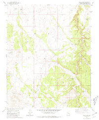
1981 Map of Mixon Tank
USGS Topo · Published 1981About this map
Cataract Canyon dominates the eastern half of this high-plateau landscape, its deep incision contrasting with the surrounding flats of the Gila and Salt River Meridian. This 1981 survey reveals a territory defined by water management in a semi-arid environment, where named catchments like Mixon Tank and Big Tank provide essential resources for cattle ranching. The presence of numerous family and location-named reservoirs, such as Pouquette Tank and Pitt Tank, reflects a 20th-century history of range improvement. In the northeast, the Four Hills rise above the drainage of Red Lake Wash, illustrating the subtle topographic relief that guided early surveyors and land users through this part of Coconino County.
Find a feature on this map
20 named features on this map. Tap any name to fly to it.
Don’t see what you’re looking for? This feature index may not catch every label — zoom into the map to look around manually.
Map Details
Editions of this 1981 Mixon Tank Map
This is the sole edition of this map. No revisions or reprints were ever made.
Other maps of this area

1886 · Chino
USGS Topo · 1:250,000

1891 · Chino
USGS Topo · 1:250,000

1922 · Williams
USGS Topo · 1:125,000

1948 · Williams
USGS Topo · 1:250,000

1954 · Williams
USGS Topo · 1:250,000

1956 · Williams
USGS Topo · 1:250,000

1960 · Williams
USGS Topo · 1:250,000
1960 · Williams
USGS Topo · 1:62,500

1961 · Williams
USGS Topo · 1:250,000

1962 · Valle
USGS Topo · 1:62,500