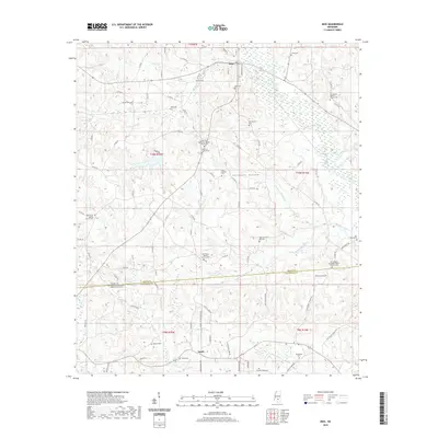
2020 Map of Mize
USGS Topo · Published 2020About this map
Sullivans Hollow serves as a geographic anchor for this portion of the Piney Woods, where the town of Mize sits near the headwaters of Oakhay Creek. The landscape is defined by its deep genealogical roots, particularly evident in the concentration of family and church-affiliated burial grounds. Family names are etched into the terrain through features like the Thomas F Sullivan Cem and Alex Sullivan Cem, while the spiritual life of the community is recorded at Zion Hill Missionary Baptist Church Cem and Providence Baptist Church Cem.
Find a feature on this map
103 named features on this map. Tap any name to fly to it.
Don’t see what you’re looking for? This feature index may not catch every label — zoom into the map to look around manually.
Map Details
Editions of this 2020 Mize Map
This is the sole edition of this map. No revisions or reprints were ever made.
Other maps of this area

1953 · Hattiesburg
USGS Topo · 1:250,000

1958 · Hattiesburg
USGS Topo · 1:250,000

1965 · Hot Coffee
USGS Topo · 1:24,000

1974 · Lone Star
USGS Topo · 1:24,000

1974 · Collins
USGS Topo · 1:24,000
1975 · Cohay
USGS Topo · 1:24,000

1975 · Taylorsville
USGS Topo · 1:24,000

1975 · Mize
USGS Topo · 1:24,000
1975 · Magee North
USGS Topo · 1:24,000
1975 · Magee South
USGS Topo · 1:24,000