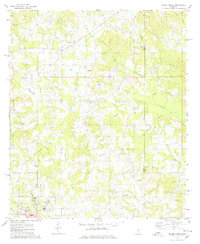
1975 Map of Magee North
USGS Topo · Published 1978About this map
The Indian Treaty Boundary cuts through this rural landscape in central Mississippi, marking a significant historical line across the Simpson and Smith county borders. In the mid-1970s, the northern outskirts of Magee show a community anchored by numerous country churches and cemeteries, reflecting the deep-rooted family history of the region. Notable landmarks include New Hope Ch, Kennedy Springs Ch, and New Bethlehem Ch, alongside family-named sites like Gregory Cem and Womac Cem. The terrain is defined by the winding course of Okatoma Creek and its many tributaries, such as Haw Branch and Hatchapaloo Creek. Industrial activity is concentrated at the Oil Field and scattered Gravel Pits, while the Icg railroad line provides a vital corridor through the southern portion of the map near Maddox.
Find a feature on this map
35 named features on this map. Tap any name to fly to it.
Don’t see what you’re looking for? This feature index may not catch every label — zoom into the map to look around manually.
Map Details
Editions of this 1975 Magee North Map
2 editions found
Other maps of this area

1935 · White Oak
USGS Topo · 1:24,000

1953 · Hattiesburg
USGS Topo · 1:250,000

1953 · Meridian
USGS Topo · 1:250,000

1957 · Meridian
USGS Topo · 1:250,000

1958 · Hattiesburg
USGS Topo · 1:250,000

1965 · Meridian
USGS Topo · 1:250,000

1968 · White Oak
USGS Topo · 1:24,000
1968 · Puckett
USGS Topo · 1:24,000

1968 · Raleigh
USGS Topo · 1:24,000

1970 · Mendenhall East
USGS Topo · 1:24,000