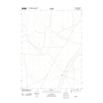
2012 Map of Mizpah
USGS Topo · Published 2012About this map
Mizpah serves as a lone point of reference in this high-desert landscape of eastern Nevada. The settlement sits near the southern end of the sheet, positioned where the Nelson Cr drainage begins to narrow between the valley floor and rising topography. The drainage system of Nelson Cr defines the local hydrology, weaving through the terrain in an area marked by a network of public land access routes. These routes, including Goshute Valley Rd, Blm Rd, and the Bureau of Land Mgmt Road 1023, emphasize the region's managed rangeland character and the importance of transit through the arid Goshute Valley.
Find a feature on this map
5 named features on this map. Tap any name to fly to it.
Don’t see what you’re looking for? This feature index may not catch every label — zoom into the map to look around manually.
Map Details
Editions of this 2012 Mizpah Map
This is the sole edition of this map. No revisions or reprints were ever made.
Other maps of this area

1953 · Spruce Mountain
USGS Topo · 1:62,500

1953 · Spruce Mountain 4
USGS Topo · 1:62,500

1955 · Elko
USGS Topo · 1:250,000

1958 · Elko
USGS Topo · 1:250,000

1962 · Elko
USGS Topo · 1:250,000

1965 · Elko
USGS Topo · 1:250,000

1982 · Currie
USGS Topo · 1:24,000

1982 · Sharp Peak
USGS Topo · 1:24,000

1982 · Mizpah
USGS Topo · 1:24,000
1982 · Mizpah Point
USGS Topo · 1:24,000