
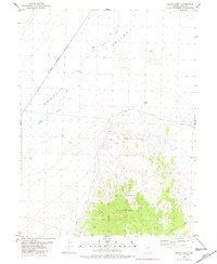
1982 Map of Mizpah
USGS Topo · Published 1982About this map
Goshute Valley defines this arid stretch of Elko County, where the Nevada Northern railroad line cuts a straight path across the desert floor. In the early 1980s, the landscape was primarily characterized by its water infrastructure and mineral exploration. Scattered across the sagebrush and alluvial fans are critical watering points for ranching or industry, including South Spruce Well, Mizpah Well, and Cordano Well. Evidence of geologic sampling and extraction is visible through numerous points marked as Prospect and a localized Gravel Pit. The drainage of Nelson Creek meanders toward the valley bottom, while the higher elevations are accessed only by a network of primitive Jeep Trails, reflecting the isolation of this high-basin environment during the late twentieth century.
Find a feature on this map
15 named features on this map. Tap any name to fly to it.
Don’t see what you’re looking for? This feature index may not catch every label — zoom into the map to look around manually.
Map Details
Editions of this 1982 Mizpah Map
This is the sole edition of this map. No revisions or reprints were ever made.
Other maps of this area

1953 · Spruce Mountain
USGS Topo · 1:62,500

1953 · Spruce Mountain 4
USGS Topo · 1:62,500

1955 · Elko
USGS Topo · 1:250,000

1958 · Elko
USGS Topo · 1:250,000

1962 · Elko
USGS Topo · 1:250,000

1965 · Elko
USGS Topo · 1:250,000

1982 · Currie
USGS Topo · 1:24,000

1982 · Sharp Peak
USGS Topo · 1:24,000
1982 · Mizpah Point
USGS Topo · 1:24,000

1984 · Currie Gardens
USGS Topo · 1:24,000