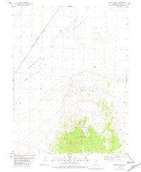
1982 Map of Mizpah Point
USGS Topo · Published 1982About this map
The Nevada Northern railroad line cuts a straight diagonal through the high desert landscape of Elko County, tracing the western edge of the Goshute Valley. This 1982 map illustrates a region defined by its water sources and mining history, centered on the prominent rise of Mizpah Point. To the south, the Dolly Varden Mountains dominate the terrain, where a solitary Mine and various canyons like Corral Canyon and Crow Canyon suggest a history of resource extraction and livestock grazing. Practical infrastructure for ranching and transit is evident through the presence of a Corral and Mizpah Well 1727, while seasonal water features like Nelson Creek and North Creek provide the only breaks in the arid valley floor.
Find a feature on this map
15 named features on this map. Tap any name to fly to it.
Don’t see what you’re looking for? This feature index may not catch every label — zoom into the map to look around manually.
Map Details
Editions of this 1982 Mizpah Point Map
This is the sole edition of this map. No revisions or reprints were ever made.
Other maps of this area

1953 · Spruce Mountain 4
USGS Topo · 1:62,500

1955 · Elko
USGS Topo · 1:250,000

1958 · Elko
USGS Topo · 1:250,000

1962 · Elko
USGS Topo · 1:250,000

1965 · Elko
USGS Topo · 1:250,000

1972 · Decoy SW
USGS Topo · 1:24,000

1982 · Currie
USGS Topo · 1:24,000

1982 · Sharp Peak
USGS Topo · 1:24,000
1982 · Dolly Varden Spring
USGS Topo · 1:24,000
1982 · White Horse Mountain NW
USGS Topo · 1:24,000