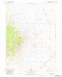
1982 Map of Dolly Varden Spring
USGS Topo · Published 1982About this map
Dolly Varden Spring and Austin Spring emerge from the eastern slopes of the Dolly Varden Mountains, providing critical water sources in an otherwise arid expanse of Elko County. The landscape is defined by the sharp transition between the high, broken ridges of the mountains and the broad, flat reaches of Antelope Valley to the east. Evidence of 20th-century resource exploration is scattered throughout the region, with various Prospect sites and Gravel Pits marking the terrain. A Pumping Sta and a solitary Well located in the southern flats suggest the ongoing management of water rights in this cattle and mining country. Transportation in the early 1980s relied heavily on a network of Jeep Trails and primitive Trails that cut through Millick Canyon, connecting the remote interior to the primary corridor of Alt 93.
Find a feature on this map
18 named features on this map. Tap any name to fly to it.
Don’t see what you’re looking for? This feature index may not catch every label — zoom into the map to look around manually.
Map Details
Editions of this 1982 Dolly Varden Spring Map
This is the sole edition of this map. No revisions or reprints were ever made.
Other maps of this area

1955 · Elko
USGS Topo · 1:250,000

1958 · Elko
USGS Topo · 1:250,000

1962 · Elko
USGS Topo · 1:250,000

1965 · Elko
USGS Topo · 1:250,000
1982 · Kinsley Mountains
USGS Topo · 1:24,000
1982 · Goshute Peak
USGS Topo · 1:24,000
1982 · Boone Canyon
USGS Topo · 1:24,000

1982 · Sharp Peak
USGS Topo · 1:24,000
1982 · White Horse Mountain NW
USGS Topo · 1:24,000
1982 · Goshute Lake NE
USGS Topo · 1:24,000