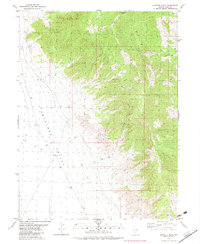
1982 Map of Goshute Peak
USGS Topo · Published 1982About this map
Goshute Peak dominates this high-altitude landscape in northeastern Nevada, where the desert floor meets the rising peaks of the Great Basin. The transition from the flat, arid expanse of Antelope Valley to the intricate drainage systems of Felt Canyon and Christmas Tree Canyon illustrates the isolation of this ranching and range country. A single Well located in the valley provides a rare point of named infrastructure, likely serving as a critical water source for livestock or travelers in this unpopulated terrain. The map is crossed by several segments of Jeep Trail and smaller Trail networks, tracing the historical paths through the mountains during the early 1980s. This survey records a remote corner of Elko County where the high desert ecology and topography dictate the limited human footprint.
Find a feature on this map
8 named features on this map. Tap any name to fly to it.
Don’t see what you’re looking for? This feature index may not catch every label — zoom into the map to look around manually.
Map Details
Editions of this 1982 Goshute Peak Map
This is the sole edition of this map. No revisions or reprints were ever made.
Other maps of this area

1955 · Elko
USGS Topo · 1:250,000

1958 · Elko
USGS Topo · 1:250,000

1962 · Elko
USGS Topo · 1:250,000

1965 · Elko
USGS Topo · 1:250,000

1972 · Lion Spring
USGS Topo · 1:24,000

1972 · White Horse Pass
USGS Topo · 1:24,000

1972 · Ferguson Mtn.
USGS Topo · 1:24,000
1972 · Spring Gulch
USGS Topo · 1:24,000

1972 · Decoy SW
USGS Topo · 1:24,000
1982 · Dolly Varden Spring
USGS Topo · 1:24,000