
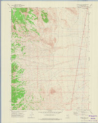
1972 Map of Lion Spring
USGS Topo · Published 1975About this map
The Goshute Mountains dominate this high-desert landscape in northeastern Nevada, rising sharply from the eastern edge of the Goshute Valley. The 1972 field check by the Geological Survey documents a remote environment where survival and travel are dictated by scattered water sources such as Chokecherry Springs, Lion Spring, and Serviceberry Spring. High points including Goshute Peak and Black Point look over a network of high-altitude drainages like Lion Canyon and the Morgan Basin. Settlement is virtually non-existent, represented only by isolated water infrastructure like Basque Well and two stations, Shafter Well No 3 and Shafter Well No 4, located on the valley floor. Movement through this difficult terrain is limited to a handful of routes, specifically a few designated Jeep Trails and a single Pack Trail that navigates the lower slopes of the range.
Find a feature on this map
17 named features on this map. Tap any name to fly to it.
Don’t see what you’re looking for? This feature index may not catch every label — zoom into the map to look around manually.
Map Details
Editions of this 1972 Lion Spring Map
This is the sole edition of this map. No revisions or reprints were ever made.
Other maps of this area

1955 · Elko
USGS Topo · 1:250,000

1958 · Elko
USGS Topo · 1:250,000

1962 · Elko
USGS Topo · 1:250,000

1965 · Elko
USGS Topo · 1:250,000

1971 · Decoy
USGS Topo · 1:24,000

1972 · Morgan Pass
USGS Topo · 1:24,000

1972 · Ferguson Mtn.
USGS Topo · 1:24,000

1972 · Ola
USGS Topo · 1:24,000
1972 · Spring Gulch
USGS Topo · 1:24,000

1972 · Decoy SW
USGS Topo · 1:24,000