
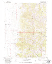
1972 Map of Morgan Pass
USGS Topo · Published 1975About this map
The high desert landscape of eastern Nevada is defined by the steep transition from the Goshute Valley floor to the peaks of the Toano Range. In the early 1970s, this area remained largely undeveloped, characterized by a network of unimproved tracks and a Jeep Trail that navigated the complex terrain of Morgan Canyon and Thirtymile Canyon. Water sources are critical identifiers for this region, with scattered locations such as Morgan Spring, Sunnyside Spring, and Isabel Spring providing life in an arid environment. The map records several vital ranching or survey landmarks, including a corral and the Spruce Shafter Fence, while man-made features like Shafter Well and Shafter Well No 2 indicate the necessary infrastructure for land use in the basin and range province.
Find a feature on this map
28 named features on this map. Tap any name to fly to it.
Don’t see what you’re looking for? This feature index may not catch every label — zoom into the map to look around manually.
Map Details
Editions of this 1972 Morgan Pass Map
2 editions found
Other maps of this area

1955 · Elko
USGS Topo · 1:250,000

1958 · Elko
USGS Topo · 1:250,000

1962 · Elko
USGS Topo · 1:250,000

1965 · Elko
USGS Topo · 1:250,000

1971 · West Morris Basin
USGS Topo · 1:24,000

1971 · Shafter
USGS Topo · 1:24,000

1971 · Pilot
USGS Topo · 1:24,000

1971 · Decoy
USGS Topo · 1:24,000

1972 · Lion Spring
USGS Topo · 1:24,000

1972 · Ola
USGS Topo · 1:24,000