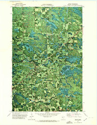
1971 Map of Mizpah
USGS Topo · Published 1974About this map
Mizpah and Gemmell anchor this northern Minnesota landscape during a period of transition in the early 1970s. The area is defined by the diagonal transit of the Burlington Northern railroad, which cuts through a complex mosaic of timberland and wetlands. Settlement patterns are concentrated along this rail corridor and the local road network, while the surrounding terrain is marked by several Gravel Pits and the winding course of Caldwell Brook. Genealogists and local historians can locate specific landmarks such as the Forest Grove Cem and a prominent Lookout Tower, which served as critical vantage points for forest management in Koochiching County. This orthophotomap combines traditional topographic contouring with aerial photography, revealing the precise boundaries between cleared agricultural patches and dense forest cover characteristic of the Northwoods.
Find a feature on this map
12 named features on this map. Tap any name to fly to it.
Don’t see what you’re looking for? This feature index may not catch every label — zoom into the map to look around manually.
Map Details
Editions of this 1971 Mizpah Map
This is the sole edition of this map. No revisions or reprints were ever made.
Other maps of this area

1919 · Lundgren
USGS Topo · 1:62,500

1919 · Gemmell
USGS Topo · 1:62,500

1919 · Norden
USGS Topo · 1:62,500

1919 · Bridgie
USGS Topo · 1:62,500

1924 · Bridgie
USGS Topo · 1:62,500

1954 · Bemidji
USGS Topo · 1:250,000

1954 · Roseau
USGS Topo · 1:250,000

1957 · Roseau
USGS Topo · 1:250,000

1957 · Bemidji
USGS Topo · 1:250,000

1958 · Bemidji
USGS Topo · 1:250,000