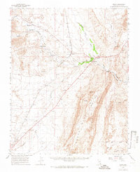
1958 Map of Moapa
USGS Topo · Published 1966About this map
The Moapa River Indian Reservation serves as a central landmark in this mid-century survey of the Muddy River valley. The Union Pacific railroad line dictates the corridor of settlement, connecting the small communities of Moapa and Glendale. The landscape is defined by the hydrological network of the Muddy River and its numerous desert washes, including California Wash and Meadow Valley Wash. This map provides significant detail for local historians, documenting scattered homesteads and infrastructure like the Home Ranch, Searles Ranch, and the West Point Cemetery. The topography transitions from the high ground of the Muddy Mountains and Muddy Ridge to the low-lying basin known as The Bowl. The presence of Warm Springs and Muddy Spring highlights the vital importance of water sources in this arid desert region during the 1950s.
Find a feature on this map
37 named features on this map. Tap any name to fly to it.
Don’t see what you’re looking for? This feature index may not catch every label — zoom into the map to look around manually.
Map Details
Editions of this 1958 Moapa Map
2 editions found

Other maps of this area

1886 · Saint Thomas
USGS Topo · 1:250,000

1893 · Saint Thomas
USGS Topo · 1:250,000

1926 · Bonelli
USGS Topo · 1:96,000

1926 · Boulder Canyon
USGS Topo · 1:96,000

1952 · Dry Lake
USGS Topo · 1:62,500

1953 · Muddy Peak
USGS Topo · 1:62,500

1953 · Overton Beach
USGS Topo · 1:62,500

1954 · Las Vegas
USGS Topo · 1:250,000

1957 · Las Vegas
USGS Topo · 1:250,000

1958 · Arrow Canyon
USGS Topo · 1:62,500