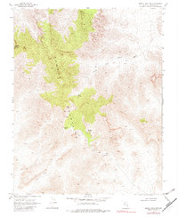
1969 Map of Moapa Peak NW
USGS Topo · Published 1980About this map
Whitmore Mine and a lone Prospect mark the sparse human footprint within the high desert terrain of Lincoln County during the late 1960s. The landscape is defined by the steep rises of the Mormon Mountains, where resource extraction attempts were situated near seasonal water sources like Horse Spring and Huckberry Spring. While the map was photoinspected in 1980, the underlying 1969 data reflects an era of remote exploration accessible primarily via rugged jeep trails and footpaths. The presence of these small-scale mining operations near Wiregrass Spring suggests a period of localized prospecting in a region otherwise dominated by complex topographic relief and wash systems, providing a clear record of the specific locations where 20th-century miners sought their fortunes in the Nevada wilderness.
Find a feature on this map
2 named features on this map. Tap any name to fly to it.
Don’t see what you’re looking for? This feature index may not catch every label — zoom into the map to look around manually.
Map Details
Editions of this 1969 Moapa Peak NW Map
2 editions found
Other maps of this area

1885 · Pioche
USGS Topo · 1:250,000

1886 · Saint Thomas
USGS Topo · 1:250,000

1886 · Pioche
USGS Topo · 1:250,000

1893 · Saint Thomas
USGS Topo · 1:250,000

1954 · Caliente
USGS Topo · 1:250,000

1954 · Las Vegas
USGS Topo · 1:250,000

1957 · Las Vegas
USGS Topo · 1:250,000

1959 · Caliente
USGS Topo · 1:250,000

1959 · Las Vegas
USGS Topo · 1:250,000

1962 · Las Vegas
USGS Topo · 1:250,000