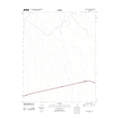
2012 Map of Moapa Peak SE
USGS Topo · Published 2012About this map
Halfway Wash dominates this desert landscape in Clark County, revealing a complex network of drainage patterns that define the local topography. The map illustrates a transitional era of infrastructure development in this part of Nevada, anchored by the East Mesa Interchange which serves as a primary access point to the region's vast open spaces. Improved transit routes like Toquop Access Rd and the Halfway Wash Rd intersect the terrain, providing critical links between the remote northern washes and the main transportation corridor. The mapping of the S Fork Rd alongside the natural drainage of Halfway Wash provides a clear view of how modern survey roads follow and intersect with the established natural landforms of the Mojave landscape.
Find a feature on this map
5 named features on this map. Tap any name to fly to it.
Don’t see what you’re looking for? This feature index may not catch every label — zoom into the map to look around manually.
Map Details
Editions of this 2012 Moapa Peak SE Map
This is the sole edition of this map. No revisions or reprints were ever made.
Other maps of this area

1886 · Saint Thomas
USGS Topo · 1:250,000

1893 · Saint Thomas
USGS Topo · 1:250,000

1954 · Las Vegas
USGS Topo · 1:250,000

1957 · Las Vegas
USGS Topo · 1:250,000

1957 · Mesquite
USGS Topo · 1:62,500

1958 · Virgin Peak
USGS Topo · 1:62,500

1958 · Overton
USGS Topo · 1:62,500

1959 · Las Vegas
USGS Topo · 1:250,000

1962 · Las Vegas
USGS Topo · 1:250,000
1969 · Moapa Peak
USGS Topo · 1:24,000