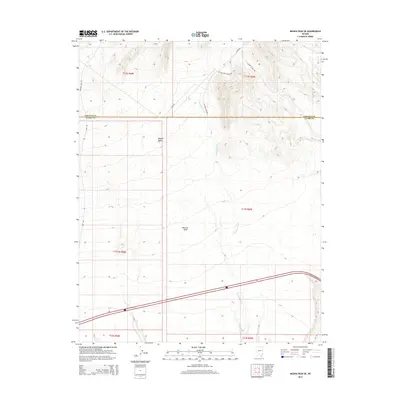
2014 Map of Moapa Peak SE
USGS Topo · Published 2014About this map
Mormon Mesa dominates the southern landscape of this Clark County region, where the arid environment of the Mojave Desert meets the high plateaus of southern Nevada. The terrain is defined by the drainage of Halfway Wash, which cuts through the center of the map, and a network of remote access roads that provide passage through this isolated territory. In the northern sections, the border between Lincoln and Clark Counties is clearly marked, intersecting with high-altitude routes like Rainbow Pass Rd. This 2014 survey documents a portion of the desert where natural landforms take precedence over human settlement, showing the specialized road infrastructure such as Halfway Wash Tower Rd and Toquop Access Rd required for modern desert management and utility access.
Find a feature on this map
16 named features on this map. Tap any name to fly to it.
Don’t see what you’re looking for? This feature index may not catch every label — zoom into the map to look around manually.
Map Details
Editions of this 2014 Moapa Peak SE Map
This is the sole edition of this map. No revisions or reprints were ever made.
Other maps of this area

1886 · Saint Thomas
USGS Topo · 1:250,000

1893 · Saint Thomas
USGS Topo · 1:250,000

1954 · Las Vegas
USGS Topo · 1:250,000

1957 · Las Vegas
USGS Topo · 1:250,000

1957 · Mesquite
USGS Topo · 1:62,500

1958 · Virgin Peak
USGS Topo · 1:62,500

1958 · Overton
USGS Topo · 1:62,500

1959 · Las Vegas
USGS Topo · 1:250,000

1962 · Las Vegas
USGS Topo · 1:250,000
1969 · Moapa Peak
USGS Topo · 1:24,000