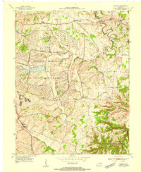
1954 Map of Moberly
USGS Topo · Published 1954About this map
The Blue Grass Ordnance Depot dominates the central landscape of this Madison County survey, its vast network of bunkers and roads etched into the terrain of the U S Military Reservation. This massive facility reflects the Cold War era infrastructure that reshaped rural Kentucky following World War II. Surrounding this industrial-military core are the older agricultural communities of Moberly and Brassfield, where local life centered on rural institutions like Goodloe Chapel and Pine Grove Ch. The presence of the Port Richmond Airfield and numerous small schoolhouses, such as Speedwell Sch and Brassfield Sch, illustrates the density of small-scale rural development prior to late-twentieth-century consolidation. Flowing through this varied topography, Muddy Creek and Hickory Lick provide the natural drainage for a region transitioning from traditional farming to strategic federal utility.
Find a feature on this map
26 named features on this map. Tap any name to fly to it.
Don’t see what you’re looking for? This feature index may not catch every label — zoom into the map to look around manually.
Map Details
Editions of this 1954 Moberly Map
This is the sole edition of this map. No revisions or reprints were ever made.
Other maps of this area

1892 · Richmond
USGS Topo · 1:125,000

1897 · Richmond
USGS Topo · 1:125,000

1952 · Alcorn
USGS Topo · 1:24,000

1952 · Berea
USGS Topo · 1:24,000

1952 · Union City
USGS Topo · 1:24,000

1952 · Palmer
USGS Topo · 1:24,000

1952 · Richmond North
USGS Topo · 1:24,000

1952 · Bighill
USGS Topo · 1:24,000

1952 · Panola
USGS Topo · 1:24,000

1952 · Moberly
USGS Topo · 1:24,000