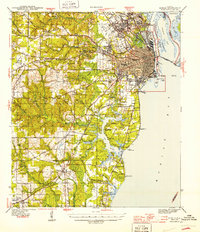
1944 Map of Mobile
USGS Topo · Published 1944About this map
Mobile's urban grid and industrial waterfront dominate this coastal survey, showing a city deeply integrated with its rail and river networks during the mid-1940s. The dense city center gives way to expanding neighborhoods like Toulminville, Crichton, and Spring Hill, where Spring Hill College and the Visitation Convent stand as prominent landmarks. The importance of the Gulf coast economy is evident in the extensive State Docks and the heavy presence of the Louisville and Nashville and Gulf Mobile and Ohio railroads.
Find a feature on this map
111 named features on this map. Tap any name to fly to it.
Don’t see what you’re looking for? This feature index may not catch every label — zoom into the map to look around manually.
Map Details
Editions of this 1944 Mobile Map
4 editions found
Other maps of this area

1921 · Grand Bay
USGS Topo · 1:62,500

1921 · Point Clear
USGS Topo · 1:62,500

1921 · Fairhope
USGS Topo · 1:62,500

1921 · Delchamps
USGS Topo · 1:62,500

1922 · Mobile
USGS Topo · 1:62,500

1939 · Daphne
USGS Topo · 1:31,680

1940 · Hollingers Island
USGS Topo · 1:31,680

1940 · Mobile
USGS Topo · 1:31,680

1940 · Mobile
USGS Topo · 1:62,500

1941 · Chickasaw
USGS Topo · 1:31,680