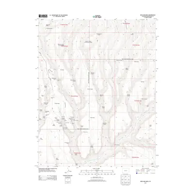
2013 Map of Moccasin Mesa
USGS Topo · Published 2013About this map
Mesa Verde National Park is defined by a landscape of high, flat-topped mesas and deep canyons where ancient dwellings are concentrated. The concentration of structures such as Cliff Palace, Spruce Tree House, and Balcony House reveals a sophisticated network of pre-historic habitations situated within the alcoves of Cliff Canyon and Spruce Tree Canyon. The map provides names for dozens of specific sites including Painted Kiva House, House of Many Windows, and the Sun Point Pueblo. This modern survey traces the access routes like Mesa Top Ruins Rd and Ruins Rd, which navigate the complex topography of Chapin Mesa and Moccasin Mesa. To the east, the Mancos River carves through Mancos Canyon, forming a natural boundary for the high-altitude mesas that once supported a thriving population.
Find a feature on this map
68 named features on this map. Tap any name to fly to it.
Don’t see what you’re looking for? This feature index may not catch every label — zoom into the map to look around manually.
Map Details
Editions of this 2013 Moccasin Mesa Map
This is the sole edition of this map. No revisions or reprints were ever made.
Other maps of this area

1912 · Soda Canyon
USGS Topo · 1:62,500

1915 · Soda Canyon
USGS Topo · 1:62,500

1956 · Cortez
USGS Topo · 1:250,000

1958 · Cortez
USGS Topo · 1:250,000

1959 · Cortez
USGS Topo · 1:250,000

1962 · Cortez
USGS Topo · 1:250,000

1965 · Cortez
USGS Topo · 1:24,000
1965 · Mancos
USGS Topo · 1:24,000
1965 · Point Lookout
USGS Topo · 1:24,000

1966 · Cortez
USGS Topo · 1:250,000