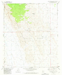
1982 Map of Mockingbird Gap SE
USGS Topo · Published 1982About this map
Oscura Mountains terrain dominates this high-desert landscape along the boundary of Socorro and Lincoln Counties. Much of the territory falls within the White Sands Missile Range, a designation that has preserved the land's rugged character while limiting modern development. A significant historical anchor on the eastern edge is the Estey City (Site), once a copper mining center, now accompanied by scattered Ruins and multiple mining Prospects. The scarcity of water in this arid environment is evident by the reliance on specific points like Kidd and Duffy Spring, Cottonwood Spring, and the uniquely named Palomas Moonshine Windmill. These features, along with Scholle Well, trace a history of ranching and survival in a difficult environment where access was primarily dictated by the location of reliable springs and man-made wells.
Find a feature on this map
13 named features on this map. Tap any name to fly to it.
Don’t see what you’re looking for? This feature index may not catch every label — zoom into the map to look around manually.
Map Details
Editions of this 1982 Mockingbird Gap SE Map
This is the sole edition of this map. No revisions or reprints were ever made.
Other maps of this area

1916 · Tularosa
USGS Topo · 1:125,000

1918 · Oscura Peak
USGS Topo · 1:125,000

1947 · Three Rivers
USGS Topo · 1:62,500

1947 · Capitol Peak
USGS Topo · 1:62,500

1948 · Chihuahua Ranch
USGS Topo · 1:62,500

1948 · Mockingbird Gap
USGS Topo · 1:62,500

1954 · Tularosa
USGS Topo · 1:250,000

1958 · Tularosa
USGS Topo · 1:250,000
1981 · Bull Gap SW
USGS Topo · 1:24,000

1981 · Tularosa
USGS Topo · 1:100,000