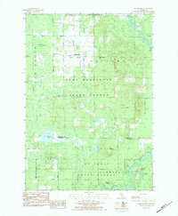
1983 Map of Moddersville
USGS Topo · Published 1984About this map
Moddersville and the surrounding borderlands of Missaukee Co and Clare Co appear here during the early 1980s, revealing a landscape defined by extensive state forest lands and complex wetlands. The northern half is dominated by the Pere Marquette State Forest, where the Modders Swamp and Spitzbergen Marsh drain toward the Muskegon River. Local history and genealogy interest centers on the two burial grounds, West Moddersville Cem and East Moddersville Cem, which flank the small settlement along Finkle Road.
Find a feature on this map
39 named features on this map. Tap any name to fly to it.
Don’t see what you’re looking for? This feature index may not catch every label — zoom into the map to look around manually.
Map Details
Editions of this 1983 Moddersville Map
2 editions found
Other maps of this area

1954 · Traverse City
USGS Topo · 1:250,000

1956 · Houghton Lake
USGS Topo · 1:62,500

1956 · Lake City
USGS Topo · 1:62,500

1957 · Harrison
USGS Topo · 1:62,500

1957 · Marion
USGS Topo · 1:62,500

1958 · Traverse City
USGS Topo · 1:250,000

1983 · Cadillac
USGS Topo · 1:100,000
1983 · Temple
USGS Topo · 1:25,000

1983 · Moddersville
USGS Topo · 1:25,000
1983 · Dinca
USGS Topo · 1:25,000