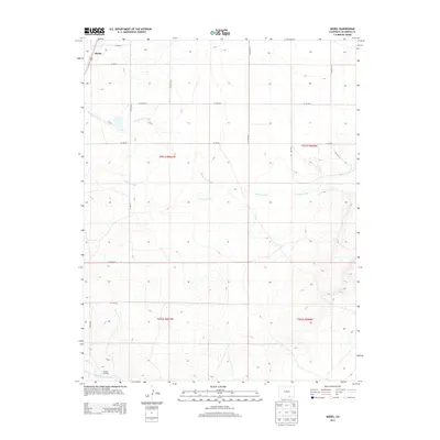
2013 Map of Model
USGS Topo · Published 2013About this map
Model sits in the high plains of Las Animas County, a landscape defined by the drainage networks of the western high desert. In the southern portion of the quadrangle, the Purgatoire River carves a deep path through the terrain, historically serving as a critical water source and navigation point marked by the Fishers Crossing landmark. The area is characterized by seasonal watercourses like Blackwell Arroyo and Luning Arroyo, which create a complex system of draws and ridges. A sparse but organized network of county roads, including Co RD-52 and Co RD-48, connects the small settlement of Model to the surrounding ranchland. This 2013 survey illustrates the enduring patterns of rural land use and the reliance on natural water features in this arid region of southern Colorado.
Find a feature on this map
22 named features on this map. Tap any name to fly to it.
Don’t see what you’re looking for? This feature index may not catch every label — zoom into the map to look around manually.
Map Details
Editions of this 2013 Model Map
This is the sole edition of this map. No revisions or reprints were ever made.
Other maps of this area

1892 · Elmoro
USGS Topo · 1:125,000

1893 · Elmoro
USGS Topo · 1:125,000

1897 · Elmoro
USGS Topo · 1:125,000

1954 · Trinidad
USGS Topo · 1:250,000

1955 · Trinidad
USGS Topo · 1:250,000

1958 · Trinidad
USGS Topo · 1:250,000

1959 · Trinidad
USGS Topo · 1:250,000
1970 · Earl
USGS Topo · 1:24,000
1970 · Mooney Hills
USGS Topo · 1:24,000
1971 · Tyrone
USGS Topo · 1:24,000