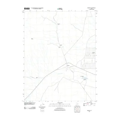
2011 Map of Modena
USGS Topo · Published 2011About this map
Modena is the central hub of this Iron County landscape, where the intersection of W Center St and Modena Main St anchors a community defined by its water management and high-desert terrain. To the north of the settlement, the Modena Cemetery lies near Modena Draw, a significant drainage feature that feeds into the Modena Draw Reservoir secured by the Modena Draw Dam. The layout reveals a distinct grid of roads to the east, including N 10000 W and N 10500 W, suggesting planned rural development or ranching parcels.
Find a feature on this map
27 named features on this map. Tap any name to fly to it.
Don’t see what you’re looking for? This feature index may not catch every label — zoom into the map to look around manually.
Map Details
Editions of this 2011 Modena Map
This is the sole edition of this map. No revisions or reprints were ever made.
Other maps of this area

1885 · St. George
USGS Topo · 1:250,000

1885 · Pioche
USGS Topo · 1:250,000

1886 · Pioche
USGS Topo · 1:250,000

1891 · St. George
USGS Topo · 1:250,000

1953 · Cedar City
USGS Topo · 1:250,000

1954 · Caliente
USGS Topo · 1:250,000

1958 · Cedar City
USGS Topo · 1:250,000

1959 · Caliente
USGS Topo · 1:250,000

1962 · Cedar City
USGS Topo · 1:250,000
1972 · Uvada
USGS Topo · 1:24,000